Enjoy this content?
Click to make it sunny!
Introduction
The Storm Prediction Center issues daily severe weather outlooks, providing critical early information helping us stay safe.
There are 3 main types of Outlooks issued by the SPC: Thunderstorm, Convective, and Fire.
For the purposes of this site/page, this page will narrow in on a few of the critical concepts related to Thunderstorm and Convective Outlooks.
Thunderstorm Outlooks
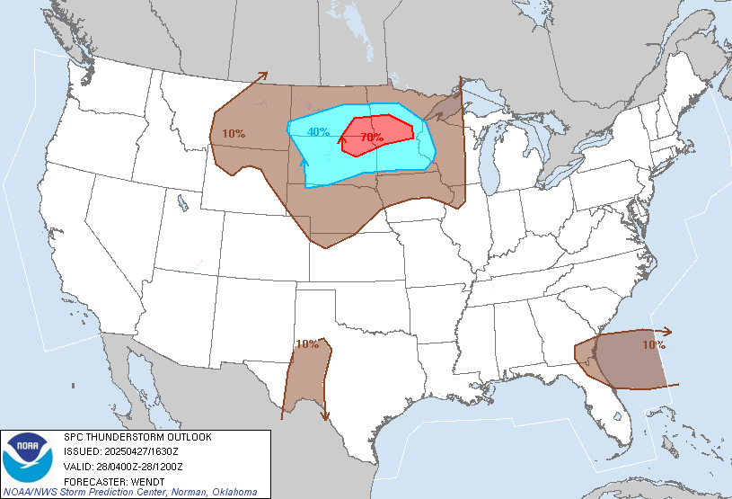
the “general thunder” outlookThe Thunderstorm Outlook shows where any thunderstorms —severe or non-severe— are expected to develop within 12 miles of a point .
This outlook uses probability contours to indicate the likelihood of hearing thunder at any point during the forecast period.
The three probabilistic forecast thresholds are: 10%, 40%, and 70%.
For outdoor event planning or understanding storm potential beyond just severe threats, this outlook provides valuable context about where the atmosphere will be unstable enough to support lightning-producing storms, even if they don’t reach severe criteria.
Convective Outlooks
The SPC’s Convective Outlooks serve as the foundation of severe weather forecasting, issued up to eight days in advance with increasing detail as the event approaches.
- Day 1 Outlook - for current day (today), includes: Categorical, Tornado, Wind, and Hail Outlooks
- Day 2 Outlook - similar as Day 1, but covering outlooks for the following day (tomorrow)
- Day 3 Outlook - is summarized and issued as Categorical/Probabilistic only
- Day 4-8 Outlook - 72-192 hours out, with either a 15% or 30% risk category issued
Outlook Publishing Schedule
Day 1 Outlook is updated multiple times, providing increasingly refined forecasts as meteorological data evolves. These outlooks offer the big picture view of where atmospheric ingredients are aligning for potential severe thunderstorm development.
Outlooks are issued on the following schedule:
- Day 1 Convective Outlook - 06:00Z , 13:00Z , 16:30Z , 20:00Z , and 01:00Z
- Day 2 Convective Outlook - 1:00AM (CST and CDT) and 17:30Z
- Day 3 Convective Outlook - 2:30 AM (CST and CDT) and 19:30Z
- Day 4-8 Severe Weather Outlook - 4:00 AM (CST and CDT)
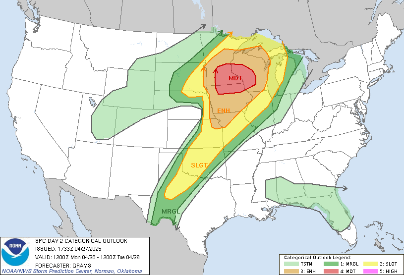
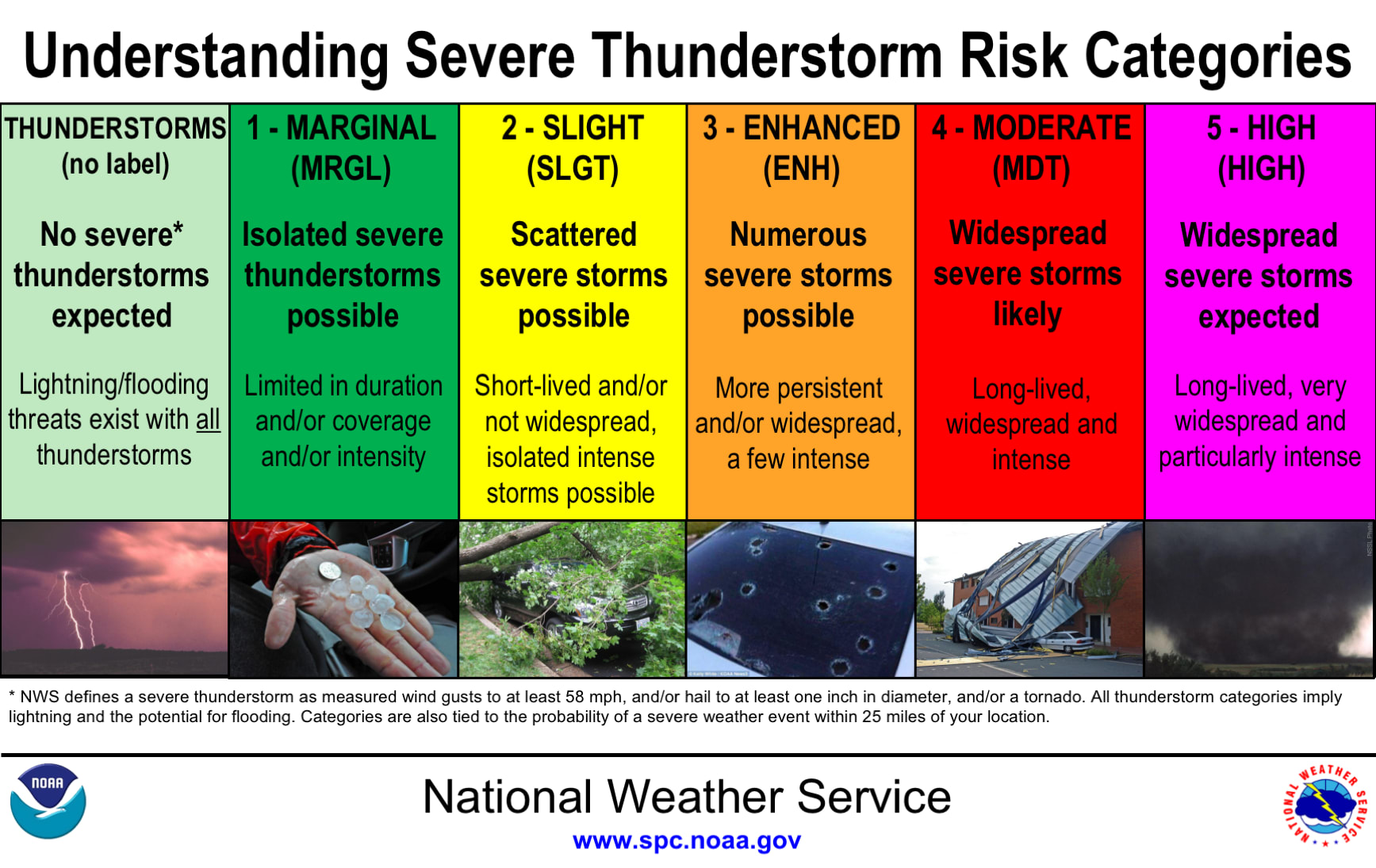
Categorical Outlook
The Categorical Outlook represents the SPC’s primary method for communicating severe weather risk to the public, using five distinct risk categories that instantly convey the expected severity and coverage of dangerous storms.
- Marginal
- Slight
- Enhanced
- Moderate
- High
Each category correspond to probabilities of severe weather within 25 miles of a point in the outlook area.
Important: More on Outlook Category Probabilities below.
The categorical system balances meteorological precision with public communication needs, allowing people to quickly grasp the relative danger without needing to understand complex atmospheric dynamics.
When displayed on maps, the distinctive and consistent color scheme provides an immediate visual representation of where the greatest threats exist across the country.
Tornado Outlook
Perhaps the most closely watched of all SPC products, the Tornado Outlook identifies regions where atmospheric conditions favor tornado development.
Using probability contours, these outlooks communicate both the likelihood of tornadoes and the potential for significant (EF2+) tornadoes.
Meteorologists analyze complex thunderstorm ingredients including: moisture, instability, lifting mechanisms, and wind shear to identify environments conducive to rotating thunderstorms. For emergency managers and the public alike, these outlooks provide crucial lead time for preparation, highlighting days when heightened awareness and access to weather information could be life-saving.
Wind Outlook
Damaging wind events, such as: isolated microbursts and widespread derecho events, receive focused attention in the SPC’s Wind Outlook.
These forecasts highlight areas with potential for thunderstorm-generated wind gusts exceeding ~60mph. The Wind Outlook is also particularly valuable for identifying the threat of organized wind-producing systems like squall lines and bow echoes.
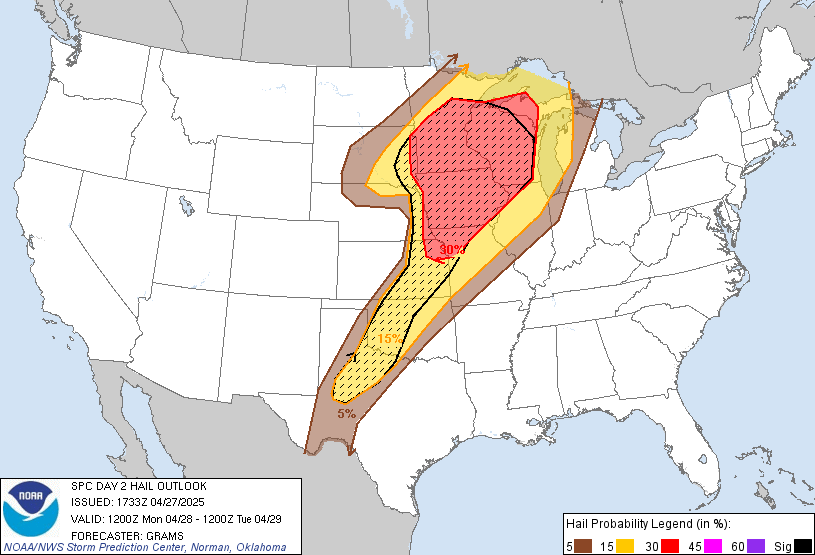
Hail Outlook
The SPC’s Hail Outlook specifically addresses the threat of damaging hailstones, using probability contours to show where significant hail (1” diameter or larger) is most likely.
Naturally, interests in this outlook include: agricultural, vehicle owners, and outdoor venues. Forecasters use factors like instability, freezing levels, and vertical wind profiles to identify regions where thunderstorms may produce hailstones capable of causing damage.
Outlook Categories
Outlooks are issued with color-coded risk categories to help communicate both the coverage and intensity of expected severe weather.
As you might expect, higher level categories are reserved for more significant severe weather. But the percentages (%) associated with each category often raise questions and confusion.
Category Probabilities
To explore these outlook probabilities, let’s look again at the Day 2 Tornado Outlook.
At a quick glance, one might read:
“There’s a 15% chance of tornadoes in Minnesota, tomorrow.”
But, this would be wrong!
So, what does 15% mean, then? And, for Moderate being quite severe… why is 15% so low?
A helpful way to think about these percentages is
an X-factor on a normal probability based on past weather events.
Let’s look at climatology history for April 28 (or as close as we can get to our Day 2 date). Below, we can see the region of MN had a 1.00% likelihood of severe weather.
We can now create a very simple ratio:
Outlook % / Climatology % = Possibility

15% / 1% = 15x
This means the SPC forecaster is stating they believe the risk of tornadoes in that region is 15 times greater than climatology (% of historical severe weather) for that day in history.
This outlook probability does not mean:
“These types of storms will produce a tornado 15% of the times.”
Using this method, you can better see how these percentages depict the severity (and rareness) of the weather events for that day and location.
Mesoscale Discussions
forecast bridge between watch and warningMesoscale Discussions (MDs) are specialized, short-term forecasts issued by the SPC when meteorologists identify weather patterns that may lead to severe weather within the next few hours.
Unlike the daily Convective Outlooks that cover broader areas and longer timeframes, MDs focus on smaller regions, aka. the “mesoscale”, where conditions are actively becoming favorable for severe weather.
You will often see phrases like: “A watch is likely… ” giving a “heads up” on confidence in upcoming events.
MDs often precede severe weather Watches by 1-2 hours, giving emergency managers and forecasters valuable preparation time.
Mesoscale Discussion Content
A typical Mesoscale Discussion includes things like: defined area of concern (map), time period, technical discussion, probability/types of severe weather expected, and watches being considered.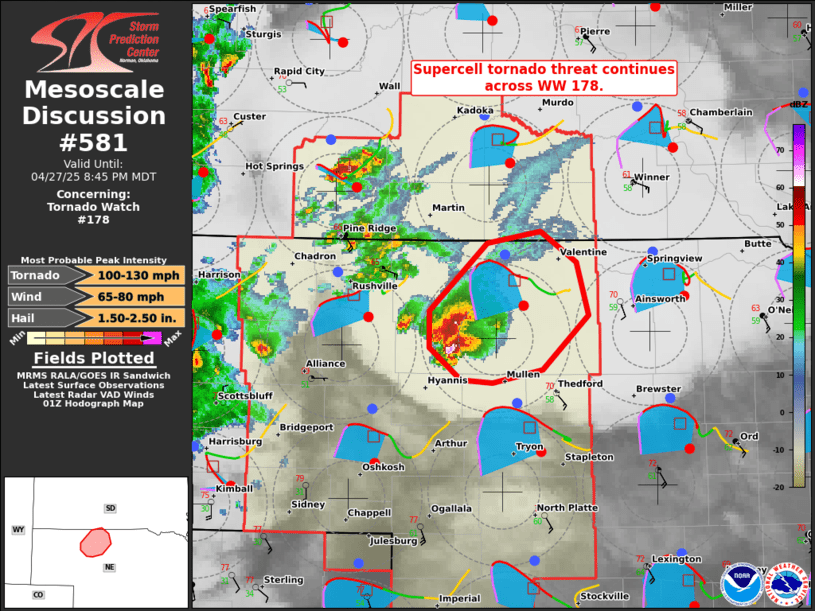
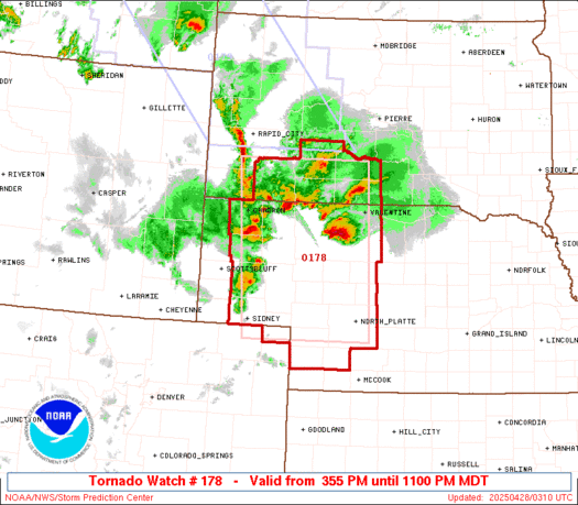
Mesoscale Discussion 0581
   NWS Storm Prediction Center Norman OK
   0847 PM CDT Sun Apr 27 2025

   Areas affected...Parts of northwest/north-central Nebraska

   Concerning...Tornado Watch 178...

   Valid 280147Z - 280245Z

   The severe weather threat for Tornado Watch 178 continues.

   SUMMARY...The supercell tornado risk continues across portions of
   northwest into north-central Nebraska.

   DISCUSSION...Several long-lived right-moving supercells have merged
   into a supercell cluster over the last hour over Cherry County
   Nebraska. The LNX VWP depicts a 50-kt low-level jet overspreading
   backed surface winds -- yielding a large clockwise-curved hodograph
   (280 m2/s2 0-500m SRH). This wind profile, combined with rich
   boundary-layer moisture (lower 60s dewpoints) will continue to
   support a supercell tornado threat with northeastward extent over at
   least the next hour.
Monitoring MDs
The SPC issues Mesoscale Discussions on their website: https://www.spc.noaa.gov/products/md/
Many weather apps and services also relay these discussion. Here are a few examples:
Radar Scope , a popular radar app, can show “Discussions” when issued
NWS SPC Twitter/X - will often share MD’s
RSS via IEMBot - IEMBot is an RSS feed aggregator and relay
And for the super nerds…use the IEMBot Search By Point page to get your very own JSON feed:
https://mesonet.agron.iastate.edu/json/spcmcd.py?lon=-93.4238&lat=44.5153

{
  "generated_at": "2025-04-28T01:15:23Z",
  "mcds": [
    {
      "spcurl": "https://www.spc.noaa.gov/products/md/2025/md0461.html",
      "year": 2025,
      "utc_issue": "2025-04-17T22:56:00Z",
      "utc_expire": "2025-04-18T01:00:00Z",
      "product_num": 461,
      "product_id": "202504172256-KWNS-ACUS11-SWOMCD",
      "product_href": "https://mesonet.agron.iastate.edu/p.php?pid=202504172256-KWNS-ACUS11-SWOMCD",
      "concerning": "SEVERE THUNDERSTORM WATCH 140",
      "watch_confidence": null,
      "most_prob_tornado": null,
      "most_prob_hail": "1.00-1.75 IN",
      "most_prob_gust": "55-70 MPH"
    },
    .....
  ]
}
Severe Weather Watches
When favorable conditions are organized for severe thunderstorms or tornadoes, the SPC may issue a Severe Thunderstorm or Tornado Watch .
Watches encourage the general public to stay alert for changing weather conditions and probable warnings.
A tornado can occur in either type of watch (or even without a watch). Tornado Watches are issued when conditions are favorable for multiple tornadoes or a single intense tornado. A Severe Thunderstorm Watch is issued when there is a forecast of organized convection producing at least 6 total severe weather events.
Watches have probabilities too, but these differ from the Outlook probabilities discussed above - they are issued by the forecaster for each watch.
Severe Thunderstorm Watch
Watch probabilities
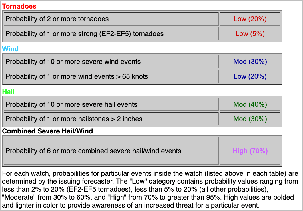
Tornado Watch
Summary
Additional Resources
SPC Day 1 Outlook
SPC Thunderstorm Outlook
SPC Outlook Info
SPC RSS Feeds